
OnGeo Intelligence the ultimate guide to high-resolution satellite imagery reports, Frequency reuse technology
OnGeo Intelligence: The Ultimate Guide to High-Resolution Satellite Imagery Reports
January 23, 2025
Satellite imagery has revolutionized the way we understand and interact with the world around us. With OnGeo™ Intelligence Reports, you can access high-resolution geospatial data effortlessly – whether you’re tracking land changes, planning investments, or monitoring environmental impacts. This cutting-edge service brings the benefits of satellite technology to your fingertips, with no need for neither subscriptions or contracts, nor specialized knowledge, skills or long-time training.
What is the OnGeo™ Intelligence Satellite Imagery Report?
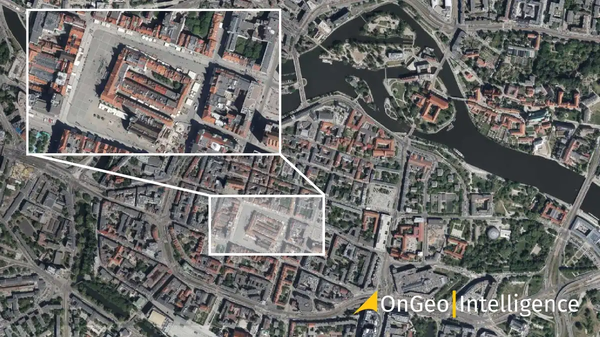
The OnGeo Intelligence Satellite Imagery Report is an advanced service providing high-resolution satellite images of any location on Earth. Delivered in a clean, easy-to-read PDF format, these reports help users visualize and analyze their areas of interest over time. Perfect for monitoring changes, these reports empower you to make data-driven decisions with precision and confidence.
With no contracts or recurring commitments, OnGeo™ Intelligence makes satellite imagery accessible to everyone. Though you may become the registered member to get the reports easier and cheaper.
Why choose OnGeo™ Intelligence?
1. High-Resolution imagery
Get access to satellite images with resolutions as fine as 30 centimeters, enhanced with AI for sharper details. Analyze everything from individual plots of land to large-scale environmental patterns.
2. Global coverage with historical data
From urban areas to remote regions, OnGeo™ Intelligence provides imagery for any location. Access historical satellite images dating back to 2008 and track changes over time.
3. Fast and reliable delivery
Your reports are ready within minutes for low-resolution scenes or up to 48 hours for high-resolution satellite imagery, ensuring you have the insights you need when you need them.
4. Advanced features
Each report includes natural-color (RGB) imagery, as well as near-infrared (NIR) data for detailed analysis. Spectral indices like NDVI, NDWI and NDMI provide insights into vegetation health, water content and soil conditions.
5. No contracts, no hassle
Unlike many services, OnGeo™ Intelligence requires no subscriptions or account registrations. Pay only for what you need and get started immediately.
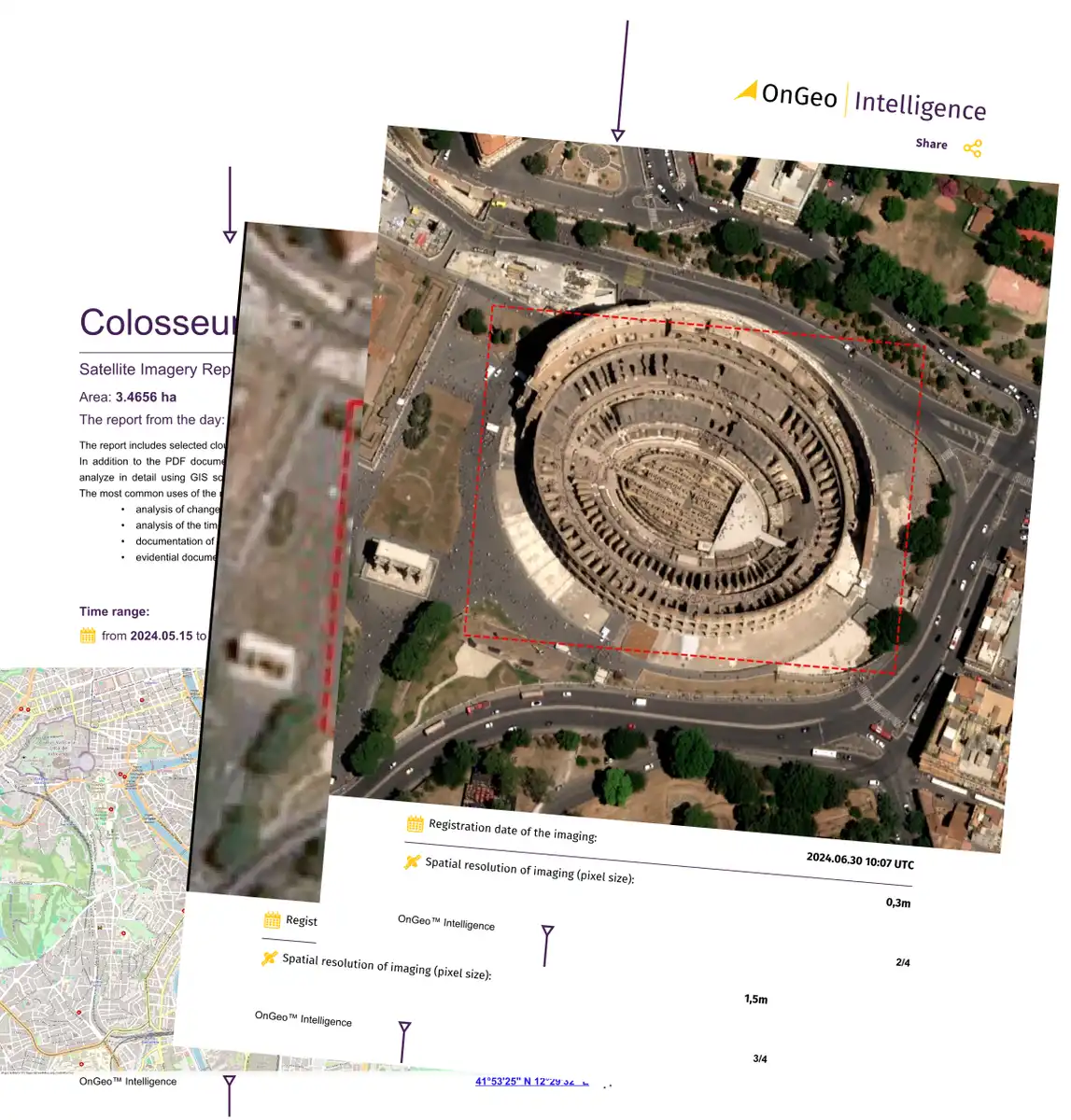
Curious About the Details? Explore a Sample Report
Wondering exactly what you’ll receive when you order a report? Check out a sample OnGeo™ Satellite Imagery Report to see how the data, maps, and analyses are presented. It’s the best way to understand the potential of this service.
Download exemplary Satellite Report OnGeo Intellitence
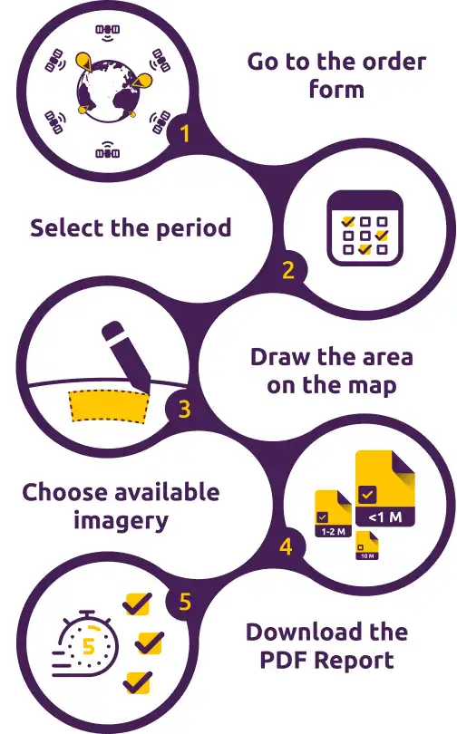
How it works?
OnGeo™ Intelligence simplifies access to satellite data with just a few steps:
- Go to the order form.
- Select the time period: Choose the timeframe for your satellite imagery.
- Define your Area Of Interest: Use the map to draw the region you want to analyze.
- Search and chose available imagery: remember to uncheck photos that show clouds over your area in the presented thumbnails of the photos.
- Order and download: Review the available images, complete the payment and receive your report quickly.
The process is intuitive, making it easy for anyone to harness the power of satellite data.
Applications of OnGeo™ Intelligence Reports
1. Property assessment and investment
Evaluate land remotely, monitor construction progress and document property boundaries without frequent site visits.
2. Environmental and agricultural monitoring
Detect drought, erosion, or flooding and optimize agricultural productivity using spectral data that tracks vegetation health and water resources.
3. Legal and administrative uses
From insurance claims to land-use disputes, timestamped satellite imagery provides credible documentation and evidence.
Empower your decisions with OnGeo™ Intelligence
OnGeo™ Intelligence Reports bring together advanced geospatial technology and user-friendly accessibility, making it the ideal solution for professionals and individuals alike. Whether you’re a property developer, environmental scientist, or agricultural planner, this service delivers the insights you need in a format you’ll appreciate. Start making better decisions with data you can trust!
Comments on this OnGeo Intelligence: The Ultimate Guide to High-Resolution Satellite Imagery Reports article are welcome.
Home Design Articles
Top 5 best TV corner wall mounts
14 Common Kitchen Design Mistakes to Avoid
How to design a kitchen: 10 essential design steps
What style of kitchen is perfect for your home
++
Building Articles
Comments / photos for the OnGeo Intelligence: The Ultimate Guide to High-Resolution Satellite Imagery Reports page welcome